 |
| Exton to Winchester (12 miles) |
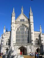
| This walk covers the western end of the South Downs Way from the small village of Exton in Hampshire. This walk climbs onto the downs, passing through beautiful open country side to the city of Winchester, the western end of the South Downs Way. Winchester is a beautiful city with a lot to see, including the Cathedral. | |
|
 |
| Petersfield to Exton (15 miles) |
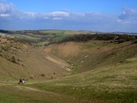
| This walk starts from the market town of Petersfield and heads south along the Hangers Way through Buriton, rejoining the South Downs Way at Queen Elizabeth Country Park. The path then passes through the park and under the A3 then climbs to the top of Butser Hill then on to Old Winchester Hill, across the River Meon and into to Exton. | |
|
 |
| Petersfield to Cocking (13 miles) |
| This walk begins from Petersfield to the north of the downs, returning to the South Downs Way near Buriton. From here the path follows farm tracks and minor roads for the first few miles then climbs to Harting Down, typical downland overlooking South Harting. The path continues east with excellent views for most of it's length before descending down to the A286 south of Cocking. | |
|
 |
| Amberley to Cocking (12 miles) |
| This walk starts from the edge of Amberley, near the working museum and crosses the river Arun before climbing back onto the downs and passing the edge of Coombe Wood to the A29. After the road the path climbs to Westburton Hill and on to Bignor Hill. Soon the path heads through woodland before descending from the downs then turning right into the village of Cocking. |
|
 |
| Amberley to Washington (6 miles) |
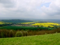
| This walk starts from the edge of Amberley, near the working museum and climbs rapidly back onto the top of the downs, offering stunning views over the Arun valley and hills to the north and to the coast to the south. The walk continues on the top of the downs all the way towards the A24 where the path descends, crossing the road, and into Washington. | |
|
 |
| Washington - Upper Beeding (7.5 miles) |
| This walk starts from the village of Washington and climbs back onto the downs, passing Chanctonbury Ring and Steyning Ring. Soon you have fantastic views over Steyning to the North and the coast near Shoreham-on-Sea to the south. Soon the path descends from the downs to the banks of the River Adur then following the river into Upper Beeding. |
|
 |
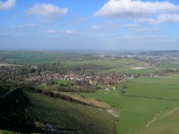
| Upper Beeding to Pyecombe (8 miles) |
| This walk begins beside the river Adur in Upper Beeding which it follows south before climbing back up onto the downs, with views over the river valley. At the top you enjoy views over the South Coast towards Brighton and to the north, soon passing the famous beauty spot of Devil's Dyke. The suburbs of Brighton are clearly visible as the path descends down to Pyecombe. |
|
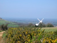 |
| Pyecombe to Lewes (7 miles) |
| This walk begins from the village of Pyecombe and climbs to the two windmills at Claytton (known as Jack and Jill). From there the path climbs to the top of the downs passing Coombe Bottom and the beautiful Ditchling Beacon, as well as a couple of dew ponds. Soon the South Downs Way turns to the right but here continue straight on to Blackcap then follow the bridleway down past the old racecourse and in to the attractive Saxon town of Lewes. |
|
 |
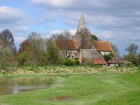
| Lewes to Southease (9 miles) |
| This walk begins from the attractive town of Lewes, a short distance from the South Downs Way. The walk begins to climb to Blackcap then back onto the South Downs Way. From here the path heads south over Balmer Down to the A27, crossing the road then round past Kingston near Lewes and on to the beautiful village of Southease, crossing the river Ouse to the station. |
|
 |
| Seaford to Southease (11 miles) |
| This walk begins from the coastal town of Seaford a short distance from the South Downs Way. Passing over Seaford Head you get fantastic views of the path over the Seven Sisters ahead then head inland to follow the banks of the river Cuckmere through Westdean, Litlington and Alfriston. From Alfirston the path climbs onto the downs offering stunning views all around before descending to Southease, a few miles north of Newhaven. |
|
 |
| Seaford - Eastbourne (10 miles) |
| This walk starts from the small town of Seaford on the coast, initially following the Vanguard Way before joining the South Downs Way at the village of Exceat. The walk then continues through the Seven Sisters Country Park, over the famous Seven Sisters cliffs to Birling Gap and onto Beachy Head. From Beachy Head it is then a short walk into the resort of Eastbourne. |
|
 |
| Eastbourne - Exceat (10 miles) |
| This walk starts at the eastern end of the South Downs Way in Eastbourne and follows the inland section of the path to Exceat. Climbing initially out of Eastbourne the path offers beautiful views around the bay towards Bexhill. The path then drops down to the pretty village of Alfriston then follows the river Cuckmere to Exceat. |
|
Every effort is made to ensure the accuracy of information on this site, but liability will not be assumed in the event of any inaccuracies. Use of the information on this site is at your own risk. If you find any errors, please use the link below. The text and photographs on this web site are all Copyright © and may not be reproduced without prior permission.